Bagyong Chedeng May 27, 2011 Update:
http://noypistuff.blogspot.com/2011/05/bagyong-chedeng-update-may-27-2011.html
May 26, 2011 5 am update is now available. Please head to:
http://noypistuff.blogspot.com/2011/05/bagyong-chedeng-may-26-2011-update-from.html
***Bagyong Chedeng Update, May 25, 2011 at 5 a.m.***Bagyong Chedeng Update, May 24, 2011 at 11:00 p.m
***Bagyong Chedeng Update from PAGASA, May 23, 2011 at 11:00 a.m.
Severe Weather Bulletin Number TWOTropical Cyclone Alert: Tropical Storm "CHEDENG" (SONGDA)Issued at 11:00 a.m., Monday, 23 May 2011 Location of Center (as of 10:00 a.m.): 795 kms East of Guiuan, Eastern Samar
Coordinates: 11.2°N, 133.8°E
Strength: Maximum sustained winds of 95 kph near the center and gustiness of up to 120 kph
Movement: West Northwest at 15 kph
Forecast Positions/Outlook: Tuesday morning: 540 kms East Northeast of Guiuan, Eastern Samar; Wednesday morning: 360 km East Northeast of Virac, Catanduanes; Thursday morning: 265 km North Northeast of Virac, Cantanduanes or 250 km East of Casiguran, Aurora
No Public Storm Warning Signals RaisedThis weather disturbance is expected not to directly affect any part of the country within the next 24 hrs.
The public and the disaster coordinating councils concerned are advised to take appropriate actions and watch for the next bulletin to be issued at 11 PM today.
***Weather Update from PAGASA: May 23, 2011, 5 a.m.
Severe Weather Bulletin Number ONE
Tropical Cyclone Alert: Severe Tropical Storm "CHEDENG" (SONGDA)
Issued at 5:00 a.m., Monday, 23 May 2011 The tropical storm East of Northern Mindanao has entered the Philippine Area of Responsibility (PAR) and was named "CHEDENG".
Location of Center(as of 4:00 a.m.): 880 kms East of Guiuan, Eastern Samar
Coordinates: 10.5°N, 134.7°E
Strength: Maximum sustained winds of 95 kph near the center and gustiness of up to 120 kph
Movement: West Northwest at 13 kph
Forecast Positions/Outlook: Tuesday morning:620 kms East of Guiuan, Eastern Samar;
Wednesday morning: 390 km East Northeast of Guiuan, Eastern Samar or
510 km East Southeast of Virac, Catanduanes; Thursday morning: 240 km East Northeast of Virac, Cantanduanes
No Public Storm Warning Signals RaisedThis weather disturbance is expected not to directly affect any part of the country within the next 24 hrs.
The public and the disaster coordinating councils concerned are advised to take appropriate actions and watch for the next bulletin to be issued at 11 AM today.
***Weather Update from PAGASA: May 22, 2011, 5 p.m.
The weather update from PAGASA posted at 5:00 p.m. on May 22 says that Typhoon "Chedeng" which has an international name of "Songda" is now 20 kilometers nearer to Northern Mindanao since the last update at 10:00 a.m. It is now estimated to be 1,050 kilometers away from east of Region X.
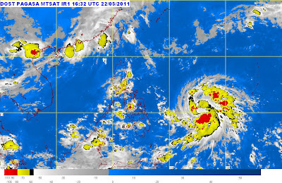 A 1:00 a.m., May 23, 2011 satellite shot of Bagyong Chedeng | Source: PAGASA
The weather disturbance has a maximum sustained winds of 85 kph near the center and gustiness of up to 100 kph. It is forecast to enter the Philippine area of responsibility Sunday night or Monday morning as it is moving at a rate of 11 kph.
PAGASA previously reported that Bagyong Chedeng will be affecting the Bicol Region.
Here's the said advisory from PAGASA:
At 4:00 p.m. today, Tropical Storm (SONGDA) estimated based on satellite and surface data at 1,050 km East of Northern Mindanao,(10.0°N, 136.2°E) with maximum sustained winds of 85 kph near the center and gustiness of up to 100 kph. It is forecast to move West Northwest at 11 kph.
Source URL: https://celebrityvma2011.blogspot.com/search/label/tropical%20storm%20songdaVisit celebrity vma 2011 for Daily Updated Hairstyles Collection
 Bagyong Chedeng (Typhoon Songda) Satellite Image as of 7 a.m.


